ACCELERATE YOUR GROWTH WITH SMART, SCALABLE TECHNOLOGY.
The DEVBRIO team has made it their mission and goal to offer the best data acquisition technologies to their clients in geophysics. We strive to find the most efficient solutions on the market. In doing so, we opt for quick data delivery using a series a refined techniques without compromising any quality.
We aim to be the leaders in our field to better serve the people who entrust us with their ideas and projects. We also aim to yield the best quality of data possible.
We provide our clients with our in-house UAV software planning tools and hardware systems that are capable of conducting high-resolution navigation in harsh geophysical survey environments, whether they be done by drones or rovers, using a variety of sensors such as GPS-RTK, LIDAR, magnetometers and more.
TURN-KEY SYSTEM
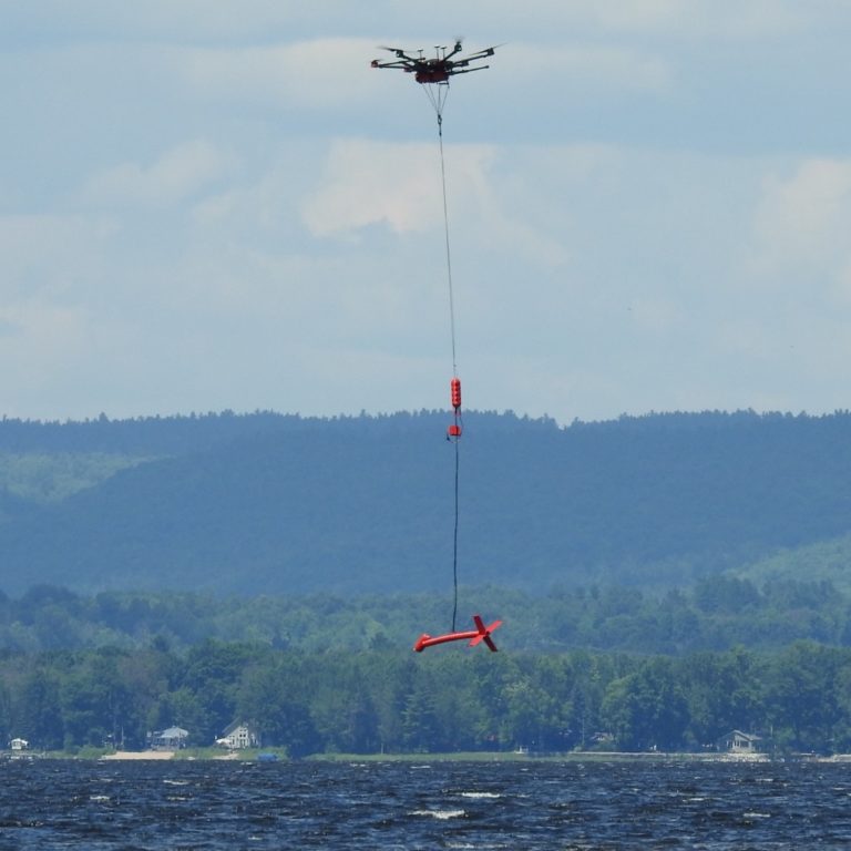
We provide a turn-key solution for drone-based magnetometer surveys, designed to deliver precise and efficient geophysical data collection. With real-time kinematic (RTK) positioning, the geophysical survey achieves centimeter-level accuracy, maximizing survey quality and efficiency.
Our system integrates cutting-edge obstacle avoidance technology, ensuring safe and reliable operation in complex environments which has been proven over 150 000 line-kilometers of acquisition over the years with regular days over 250 line-kilometers of acquired data with a two-person crew. We offer comprehensive support and training, our experts provide hands-on guidance helping you achieve optimal results with confidence. More than 260 UAV mag survey projects have been successfully carried out by our partners in Canada, USA and Greenland.
ROBOTICS
We have integrated our drone-based magnetometer surveying technology with a wide range of UAV platforms, ensuring flexibility and adaptability for diverse operational needs. Our system is fully compatible with industry-leading UAVs, including DJI M600, RHEA 160, Arcsky X55, MMC Skylle 1550P and others, allowing users to leverage the best platform for their specific survey requirements. Whether utilizing DJI, Ardupilot or PX4 flight controllers, our technology adapts to various mission profiles with ease. This cross-platform compatibility empowers our clients with greater choice, ensuring they can execute high-quality geophysical surveys with their preferred drone.
DATA PROCESSING AND SOFTWARE
Our team of skilled programmers and engineers specializes in developing intuitive and user-friendly Graphic User Interfaces (GUIs) that enhance the usability of our advanced planning tools. Each interface is designed with efficiency in mind, integrating custom functions tailored to meet the specific needs of our clients. By streamlining workflows and simplifying complex processes, our GUIs empower users to achieve their goals with precision and ease.
In addition to intuitive software design, we develop personalized data processing solutions powered by our proprietary algorithms. These refined solutions are optimized for speed and accuracy, ensuring rapid data turnaround times without compromising quality. Whether handling large-scale geophysical datasets or intricate survey results, our advanced processing capabilities provide clients with fast, reliable, and actionable insights.
ELECTRONICS
We are no strangers to working with embedded systems everyday. With strong electrical background and knowledge, we design our own electronic instruments from start to finish. From PCB design, to FPGA implementation, to advanced signal processing to system modeling and simulations, our engineers work with the software team to come up with the best control systems and data acquisition solutions.
We are also very familiar with different magnetometer systems used for geophysical surveys and we have been able to tune our electronics in such a way to maximize magnetometer data acquiring.

MECHANICAL
Our instruments wouldn’t be able to withstand the demanding surveying conditions that come with geophysical work without proper spatial awareness and materials.
The mechanical team uses state-of-the-art 3D modeling techniques to design and fabricate all proprietary hardware for our data acquisition systems.
ENVIRONMENTAL AWARENESS
It is the team’s duty to acknowledge and assess all environmental matters related to every step of a project. Whether it be from the research and development stage, the planning stage, the execution stage or the submitting stage, we will always find the route that minimizes our ecological footprint.
At DEVBRIO, we make a special effort to sort our waste. From old circuit boards to 3D printed ABS parts, we have implemented an easy and effective procedure to ensure that all types of waste are separated and disposed of properly.
OUR VALUES
We are committed to creating valuable connections and relationships with our clients and partners. We make sure our work exceeds all expectations.
We have a particular fondness for the environment and we feel it is important to incorporate an eco-conscious mindset while taking on projects.
We ensure that our employees have the best quality of life while working at the DEVBRIO office.
WHO WE ARE

Located in the Ottawa-Gatineau region in Canada, we are a team of motivated engineers with over 30 years of combined experience in software, electronics and operations, dedicated to advancing geophysical surveying technology and pushing the boundaries to deliver reliable, easy-to-use solutions for the mining industry.
Our expertise lies in developing innovative, high-precision solutions that streamline data collection and analysis.
Our experience with field operations allows us to better understand the needs of our clients to ensure the solutions we offer are the most robust and efficient possible.